4 Locations in the Geospatial World
Explain the concept of a geodetic datum
Describe the shape of the Earth and how it affects spatial measurements
Identify common global and local datums
Recognize how differences in datums can lead to positional errors in GIS data
We live in a geospatial world, where we describe places using names, landmarks, or directions in daily lives. Across fields such as science, agriculture, business, urban planning, public health, civil engineering, and navigation, it is essential to go beyond simple descriptions and use precise, standardized systems to define and record locations on Earth surface. In such cases, we use coordinate systems to assign numerical values (such as latitude and longitude) to pinpoint every location across the globe in a systematic and consistent way.
A coordinate system provides a standardized framework for recording, analyzing and sharing spatial information. It enables us to accurately capture, analyze and visualize real-world processes, whether it is to examine the migration patterns of birds, map cropland performance, monitor real-time locations of airplanes, analyze the spread of an infectious disease, or identify hot spots in a city during a heat wave. Different agencies and organizations have developed various coordinate systems suitable for different tasks, such as global navigation or local mapping.
All spatial data—data with location information—is based on some form of coordinate system. To effectively use existing spatial data or create new datasets, we need to understand what coordinate systems are and how they are established. The first and essential step to develop such coordinate systems is to model the shape of the Earth. So, let’s start here.
4.1 Shape of the Earth
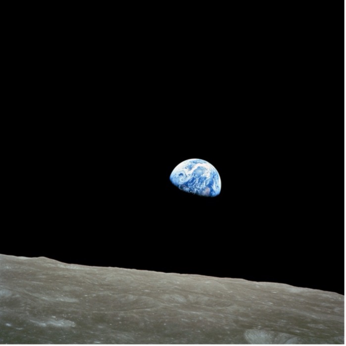
The development of modern space technologies makes it easier to study Geodesy—the fundamental properties of the Earth, including its geometric shape, its orientation in space, its gravity field, as well as the changes of these properties over time. For instance, the Earthrise Figure 4.1 was a photo taken by NASA astronaut William “Bill” Anders on December 24, 1968, during the Apollo 8 mission. For the first time, the photo showed the Earth—a beautiful, fragile blue sphere—rising from the barren lunar surface, revealing its shape, location and unity in the vastness of space. Fifty years to the day after taking the photo, Anders observed, “We set out to explore the moon and instead discovered the Earth.” However, people’s curiosity about the shape of the Earth goes far back in the history, long before these space technologies were available.
4.2 The rise of the spherical earth
Based on a few empirical observations, the ancient Greeks were able to establish a spherical earth. Aristotle (384 – 322 B.C.) provided some of the earliest empirical evidence for spherical earth, including 1) Ships disappear hull-first when they sail over the horizon; 2) Earth casts a round shadow on the moon during a lunar eclipse; 3) Different constellations are visible at different latitudes. Based on these observations, Aristotle concluded that “Again, our observations of the stars make it evident, not only that the Earth is circular, but also that it is a circle of no great size. For quite a small change of position to south or north causes a manifest alteration of the horizon” (Aristotle).
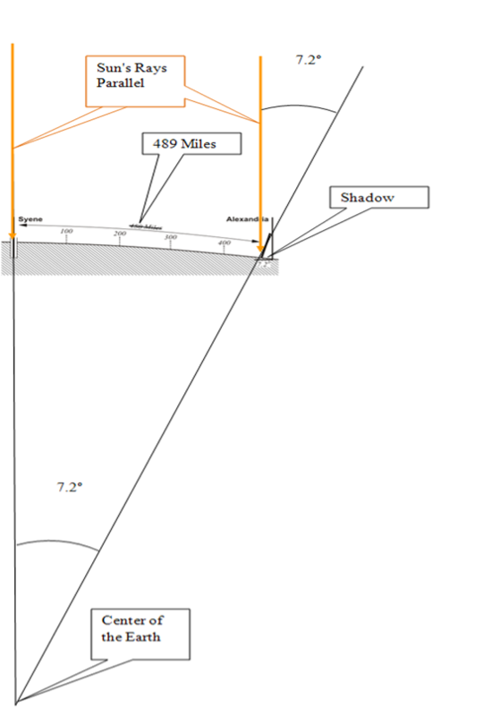
The ancient Greeks not only established the spherical earth but also calculated the earth’s circumference. In 200 BC, the Greek mathematician and geographer Eratosthenes noticed that objects in Syene (the city now known as Aswan located in Egypt) casted no shadows at noon in midsummer, indicating that the sun was directly overhead. Meanwhile, a pillar casted a shadow at the same time in Alexandria, which is located 489 miles north of Syene. The angle between the shadow and the pillar was 7.2 degrees. Based on the idea that the earth was a sphere, Eratosthenes reasoned the angle between Alexandria and Syene at the center of the Earth had to be 7.2 degrees, which is 1/50th of 360 degrees Figure 4.2. Based on this assumption, Eratosthenes calculated the circumference of the entire planet as
$$\text{Circumference} = 50 \times 489 \text{ miles} = 24{,}450 \text{ miles}$$
This was very close to being right (the equatorial circumference is ~24,901 miles and the polar circumference is ~24,860 miles).
With the fall of Roman empire, knowledge about the shape and size of the Earth in Europe became fragmented. While Europe went through intellectual decline, the Islamic world was preserving and expanding upon Greek and Roman knowledge by translating and studying texts from these previous times (the Islamic Golden Age). Unlike figures such as Aristotle, who heavily relied on deductive logic, the Islamic scholars emphasized on empirical verification, believing that theories should match observations but not the other way around. They confirmed the spherical nature of the Earth and refined earlier calculations of Earth’s circumference. For instance, Persian scholar Al-Biruni made highly accurate calculations of Earth’s radius using trigonometry and the height of a mountain. His value of the Earth’s radius (~6340 km) was within 1% of the modern accepted mean radius of 6,371 km, or different of only 2% from the mean radius of curvature of the reference ellipsoid at the latitude of measurements (Sparavigna 2014).
4.3 The oblate or prolate spheroid?
It is not until the 17th century that development of physics, especially the understanding of motion and forces, drove new ideas about the shape of the Earth. René Descartes, the French mathematician and philosopher, proposed a prolate earth model, which is elongated at the poles and flattened at the equator. Based on different underlying physics theories, Isaac Newton and Christiaan Huygens argued for the oblate Earth model—a sphere flattened at the poles and bulging at the equator. In his 1687 masterpiece, Philosophiae Naturalis Principia Mathematica (Mathematical Principles of Natural Philosophy), Newton calculated the radii of earth and reported that the earth is higher under the equator than at the poles, and that by an excess of about 17 miles. This value is close to the right number, which is 13 miles (Radius at the equator = 3963 miles or 6378 km; and Polar radius = 3950 miles or 6356 km). The debate between the two earth models was settled in the 18th century, when two competing French expeditions, one to the equator in Peru and another to the Arctic Circle in Lapland, were sent out to measure the length of a degree of latitude at different locations, which conclusively proved Newton’s oblate Earth model.
4.4 Geoid
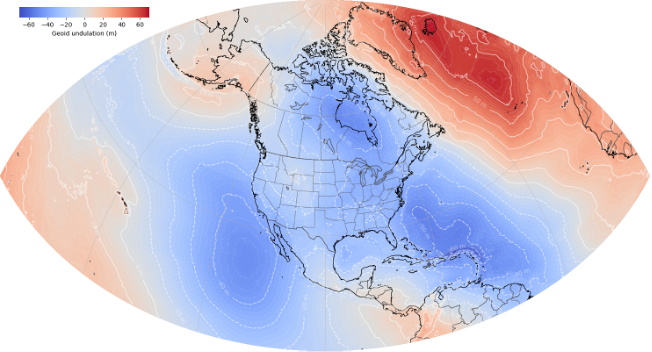
The real resolution of the shape of the earth happened with the Space Age the 20th century. Satellite based earth observations provide a consistent method to measure the Earth’s shape and its subtle changes. Morden gravity missions such as the NASA Gravity Recovery and Climate Experiment (GRACE) mission can measure changes in the Earth’s gravity field, which is directly related to the distribution of mass on and within the planet, offering an invaluable method to measure the Earth’s shape. Using the Earth’s gravity field, we are now able to create a Geoid that is the constant gravity surface of the earth Figure 4.3.
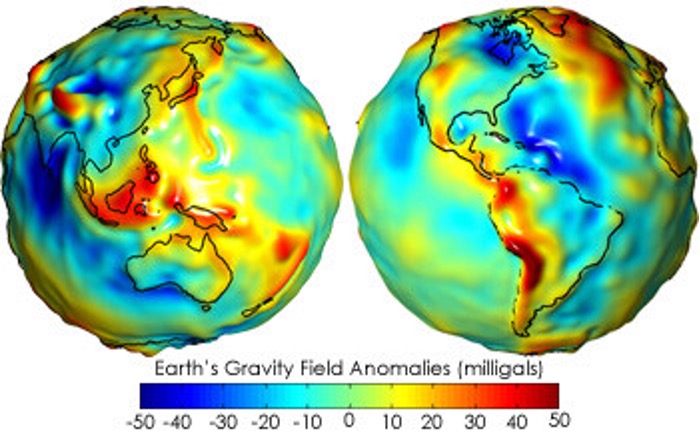
The geoid is not a perfect, smooth sphere. Instead, it is a bumpy, irregular surface because the Earth’s mass is not distributed perfectly evenly. For example, areas with more mass (like large mountain ranges or denser rock underground) have a stronger gravitational pull, which causes the geoid to bulge outward. Conversely, areas with less mass (like deep ocean trenches or less dense rock) have a weaker pull, and the geoid dips inward.
The most fundamental property of the geoid is that it is an equipotential surface, meaning that at every point on the geoid, the force of gravity is the same, and it acts perpendicular to the surface. For a surveyor, this means a plumb line (a string with a weight at one end) will always be perfectly perpendicular to the geoid at any location, and a level surface (like a calm body of water) will always be perfectly parallel to the geoid. Thus, Geoid is often defined as a hypothetical Earth surface that represents the mean sea level in the absence of winds, currents, and most tides. It is what the ocean surface would take under the influence of gravity of earth only (not affected by any force other than Earth’s gravity, e.g., wind, waves, the Moon…). The geoid is the name given to the shape that the Earth would assume if it were all measured at mean sea level - close to but NOT equivalent to actual mean sea level.
4.5 Datum
While the geoid is able to capture the Earth’s shape in detail, it is too complex and irregular to model or use as the reference surface for locations on the Earth surface. Thus, an ellipsoid (aka spheroid)–a simplified smooth surface–is used instead . However, the discrepancy between the geoid and ellipsoid produces a source of error to locations .
Here, we define the term datum as a reference surface of the earth that is used for plotting locations across the globe. In this case, an ellipsoid with the origin in latitude and longitude and orientation is used to represent datum. The origin illustrates at which the ellipsoid is tied to a known (often monumented) location on or inside Earth (not necessarily at 0 latitude 0 longitude), indicating how to fit the ellipsoid to geoid. Orientation is how we position the ellipsoid, after we tied it to a known location – we still have some limited capacity to move it around relative to geoid.
Essentially, datum is a mathematical model to reference a coordinate system against Figure 4.4. In reality, people use different datums for different geographical areas, because the Earth has an imperfect, lumpy shape, and no single simple mathematical model can perfectly represent it everywhere. Thus, datums are designed to be the best possible fit for a specific region or for the entire globe. For instance, surveyors and cartographers would create a datum that provided the best fit for their particular country or continent to allow them to choose a reference ellipsoid that most closely matched the curvature of the Earth in that specific region. This approach made mapping and surveying highly accurate within that region, but it created significant problems when trying to connect different regional systems. For example, the North American Datum of 1927 (NAD 27) was a local datum that was extremely accurate for North America but would be offset by hundreds of meters or more if used in Europe or Asia.
The common horizontal datums used in North America including the North American Datum of 1927 (NAD27), the North American Datum of 1983 (NAD83) and the World Geodetic System of 1984 (WGS84).
The NAD27 datum was developed for measurements of the United States and North America. It has its center positioned at Meades Ranch in Kansas. The NAD83 datum was developed by the National Geodetic Survey and Canadian agencies in 1986. It is used as the datum for much data for the United States and the North American continent as a whole. In the 1990s, the National Geodetic Survey (NGS), in collaboration with individual states, undertook a major project to update the NAD83 datum by establishing a new, more precise network of reference points across the United States (High Accuracy Regional Network of fitted points; HARN).
The WGS84 datum was developed by the U.S. Department of Defense and is used by the Global Positioning System (GPS) for locating points worldwide on Earth’s surface (a global datum). WGS84 has been revised six times since its original realization in 1987. The most recent version is WGS84 (G2139) implemented on 3 January 2021. Originally, the difference between WGS84 (as rolled out in 1987) and NAD83 (as first introduced in 1986) coordinates was so small that transformation was unnecessary. That is no longer the case when it comes to NAD83 2011 (2010.0) and WGS84 (G1762).
In order to minimize coordinate changes over time, NAD 1983 is tied to the North American, Pacific (for Hawaii, Guam, etc.), and Marianas tectonic plates, while WGS 1984 is tied to the International Terrestrial Reference System (ITRF) which is independent of the tectonic plates. Over time, the two coordinate systems have become increasingly different and the difference can be ~1 to 2 meters within the continental United States.
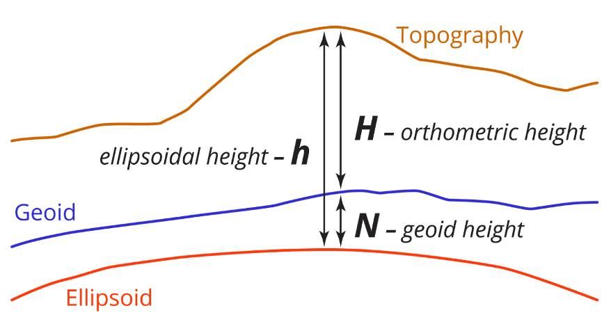
Similar to the horizontal datum, a vertical datum refers to a surface of zero elevation to which heights (elevations) of various points are referenced using either an ellipsoid (ellipsoidal datum) or a specific geoid (orthometric datum) as a reference surface for height. Unlike a horizontal datum, a three-dimensional ellipsoidal datum provides the foundation for accurate determination of ellipsoidal height, which is the height of that same point of the Earth surface is the vertical distance from that point to the ellipsoid. On the contrary, orthometric height in North America is defined as the vertical distance measured from adopted geoid to the ground surface height, along a line that is always a right angle to all intervening equipotential surfaces. Considering the fact that the geoid is a surface of constant gravitational potential that closely approximates the mean sea level, whenever you see elevation data described as “X” feet/m above or below sea level, it is referring to the orthometric height. A related definition is the geoid height, which is defined as the difference between the geoid and ellipsoid, describing the height of the Earth’s geoid surface above or below an idealized reference ellipsoid Figure 4.5.
4.6 NAPGD2022
Note that the North American–Pacific Geopotential Datum of 2022 (NAPGD2022 Figure 4.6) will serve as the future geopotential datum of the National Spatial Reference System (NSRS). It encompasses three regions: the North American–Pacific region, Guam and the Commonwealth of the Northern Mariana Islands, and American Samoa. This datum provides the information needed to generate consistent orthometric heights, geoid undulations, gravity anomalies, deflections of the vertical, and other gravity-related geodetic quantities.
4.7 Geographic Coordinate System (GCS)
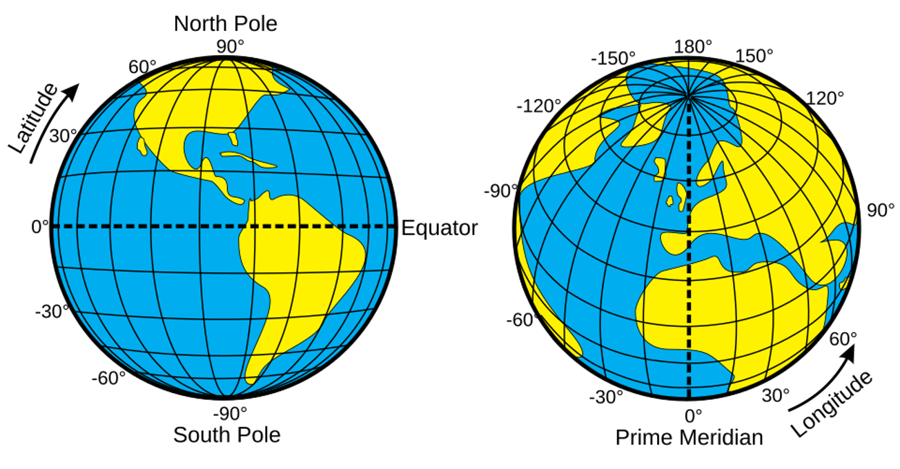
Once the datum is fixed, we can use the datum to define a geographic coordinate system, which is a global reference system for determining the exact position of a point on Earth. In addition to a datum, a GCS includes a prime meridian that specifies the location of 0° longitude, and an angular unit often in degrees Figure 4.7. Latitude (a.k.a. parallels) is used to represent the east-to-west direction and equator is defined as the starting point of 0 degree latitude. Longitude (a.k.a. meridians) is used to represent the north-to-south direction (the North Pole to the South Pole). The International Meridian Conference (1884, US) defined the use of the meridian at the Royal Observatory in Greenwich, England as the zero reference line (prime median).
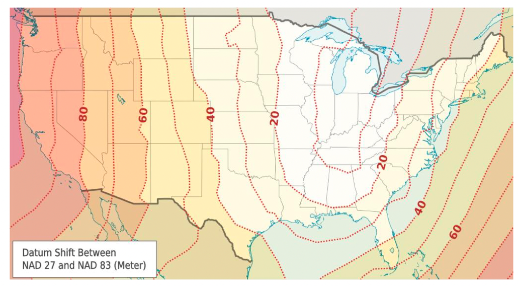
Since each datum defines a slightly different size, shape, and position of the Earth’s reference ellipsoid, a location’s coordinates (latitude and longitude) will also change when you switch datums. A datum shift describes the difference in coordinate values for the same point on Earth when measured against two different datums. This difference can range from a few centimeters to hundreds of meters, depending on the datums involved and the location of the point Figure 4.8. A datum transformation—a set of math formulas— can be used to convert point coordinates from one datum to another. However, errors up to several meters may occur during the transformation and errors accumulate with repeated transformations, because datum transformation is not an exact, one-to-one conversion but a mathematical process that uses a set of parameters (translations, rotations, and scale factors) to convert coordinates from one datum to another. These parameters are themselves estimates based on a best-fit model between the two datums, and they contain their own uncertainties. Thus, converting datums should be done only when necessary (use the fewest transformations possible), and care should be taken in choosing the best method. It is also suggested that using the same transformation each time to transform between these two datums. It is worth noting that dealing with some of the old datums may be problematic because their datum may not be well defined using the modern mathematical parameters.
4.8 References
Aristotle On the Heavens. The Works of Aristotle: Oxford University Press, 297-298.
Sparavigna AC. 2014. Al-Biruni and the Mathematical Geography. PHILICA.